
Disturb me, compel me. It is not true
That “no man is happy,” but that is not
The sense which guides you. If we are
Unfinished (we are, unless hope is a bad dream),
You are exact. You tug my sleeve
Before I speak, with a shadow’s friendship,
And I remember that we who move
Are moved by clouds that darken midnight – Delmore Schwartz, American Poet 1913 – 1966
As an early morning orange sun creeped above scalloped mountains, I crossed Bow River and drove the short distance to Lake Louise. Surprisingly, the two tiered parking lot was nearly full, but I managed to find a spot near the back of the upper lot. Walking toward a small stand of trees that separates parking from a broad cement walkway leading to the lake, I passed vehicles from each Canadian province, several U.S. states and heard snippets of conversations in multiple languages. Stepping into the open, Fairmont’s imposing Chateau Lake Louise, leans against white streaked mountains, a snowglobe waiting to be shaken. With her cream walls, slate blue roof line and green courtyards, one of Canada’s grand railway hotels, built in the early decades of the 20th century by the Canadian Pacific Railway, carries no pretense other than that granted to her over time. She is a portrait of understated elegance.
Named after Princess Louise Caroline Alberta, the daughter of Queen Victoria, my first glance of Lake Louise catches me off guard. The view is stunning. Otherworldly in its beauty and proximity. Clear turquoise waters rest beneath wide sloping shoulders of lodgepole pine and Engelmann spruce. Where the lake narrows, Victoria Glacier rests in a hollow of granite, draped over the upper slopes of Mt Victoria. With a few short steps I am at the water’s edge. I kick off my shoes and drop my feet into the ice cold water, where I sit for over an hour, my senses lurching, scrambling to find context. After a long hike along the lake’s northern shore and a dish of chocolate ice cream on the Fairmont lawn, snippets of sing-song voices followed me back to the van.


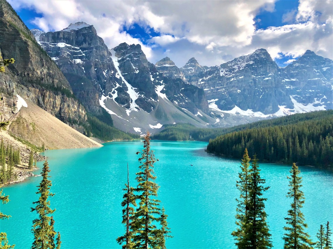
At an elevation of 6,183 feet, 1,000 feet above Lake Louise, nestled among a palate of forest green, suede glacial debris and granite marbled in white, Moraine Lake lays cradled in the Valley of the Ten Peaks. Standing on the shoreline, steps from a rustic glass fronted Moraine Lake Lodge, the water appears lightly hued blue. It is only when you climb to a vantage point above the lake and look down, that her true color becomes visible.
Rockpile Trail follows the actual moraine, a glacially formed accumulation of unconsolidated glacial debris – regolith and rock – normally consisting of rounded particles ranging from large boulders to minute glacial flour. In this case, the moraine is a jumble of boulders varying wildly in size, pushed to the southern tip of Moraine Lake, marking the maximum advance of the glacier. Scrambling to the top of the 80 foot rockpile, the lake kneels at my feet. Light refracting off rock flour deposited and suspended in the glacier fed lake, allow brilliant blues and greens to mingle, creating liquid turquoise. Like Lake Louise, it takes a moment to comprehend such vibrant color. Surrounded by elements of landscape – mountains, trees, rock – in colors and shades that match your mind’s expectations, it’s like seeing a bright red mountain. Or a forest of deep purple. I’m looking down on a fingerprint of nature in a color other than what my brain is used to seeing. Even more than Lake Louise, it is disconcerting, yet as beautiful as anything nature has put in front of me. I move between outcroppings, each view rivaling the last. A single wooden canoe glides across the water, carving a sharp V that slowly expands until it meets the shore.

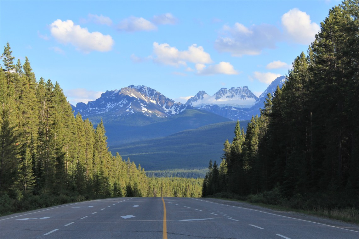
Canadian Highway 93 runs south through Banff and Kootenay National Parks, handing me off to Canadian Highway 95, at Radium Hot Springs, before stretching another 82 miles south to the U.S. border. Unlike my northern route of a few days ago, where rolling farmlands of Alberta dominated the eastern horizon, today I am following the spidery Kootenay River through The Valley of Ten Thousand Peaks in the province of British Columbia. A trench scoured into rock by retreating glaciers and shifting plates, separates the Canadian Rockies to the east and from the Columbia, Omineca and Cassiar mountains to the west. A broad plain of rivers and lakes flowing between gallery walls of blue-grey granite, jagged peaks bowing to the north before introducing me to a new razor edged sentinel. Light green hummocky landscapes gaze up from the valley, lavender wildflowers scattered in tribute to the mountains majesty. Only when I reach the U. S. border, do I realize that I have been driving for several hours.
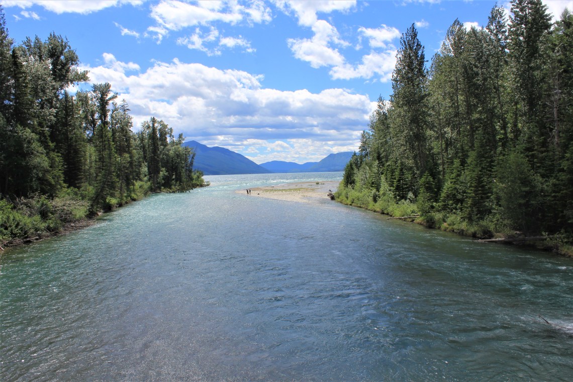
Whitefish Lake State Park is about two miles west of Whitefish, Montana and 45 miles from Apgar Visitor Center, in Glacier National Park. After a couple slices of pie at Second Street Pizza and a good night’s sleep, I’ll be one of the first travelers to cross Glacier on one of the most beautiful, harrowing road’s in the world. It is the evening of June 22nd and Going-to-the-Sun Road opens in the morning.
Local legend, as relayed in a 1933 Department of the Interior press release, tells the story of “the Blackfoot deity, Sour Spirit, who came down from the sun to teach young braves the basics of hunting. On his way back to the sun, Sour Spirit had his image reproduced on the top of Going-to-the-Sun Mountain for inspiration to the Blackfeet.” In 1932, after three decades of construction, and a cost of more than $2,000,000, the first automobile drove the entire length of the Going-to-the-Sun Road. Formally opened in a special ceremony at Logan Pass on July 15, 1933, Governor Frank H. Cooney stated that “There is no highway which will give the seer, the lover of grandeur of the Creator’s handiwork, more thrills, more genuine satisfaction deep in his being, than will a trip over this road.” He has yet to be proven wrong. In 1983 Going-To-The-Sun Road was added to the National Register of Historic Places, and in 1985 was made a National Historic Civil Engineering Landmark.
Apgar Visitor Center, below the southern shore of Lake McDonald, Glacier’s largest lake at over 10 miles long and 472 feet deep, was a few hours from opening for the day when I entered the park. With Lake McDonald down a sloping hill, the road is narrow, curtains of trees and yellow grasses to my right. As the road begins to climb, patches of grey scree dots dirty snow, as the slight shoulder ends and you’re pressed against a wall of clawed rock. Unevenly spaced square blocks of stone provide a false sense of security to those descending westward, gazing at sheer drops into steep valleys of cedar forest. Continuing to climb, heavy snow now rises above my roofline, wrinkled by horizontal plow marks. In the sun, runoff shimmers across the ever narrowing road. Slender waterfalls on distant mountains, appear to be drawn in white crayon.

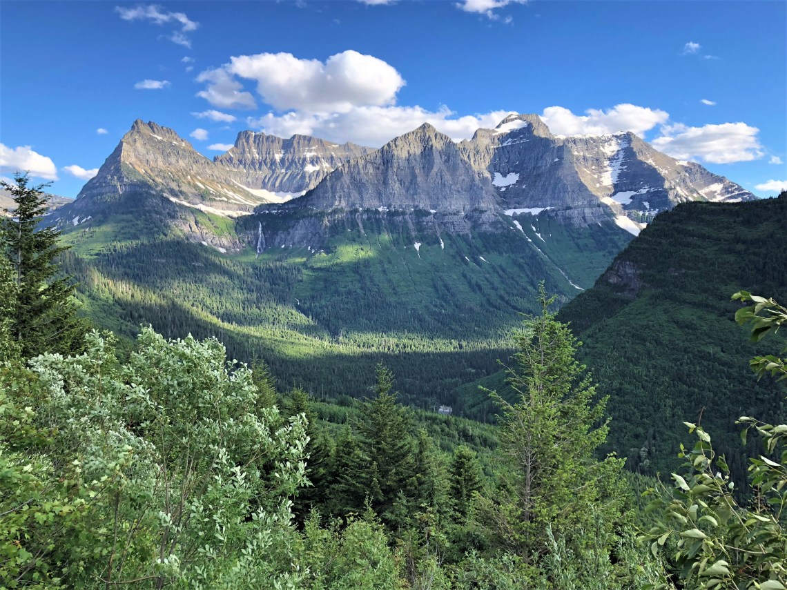
At 192 feet long, a tunnel bored into rock appears on a narrow, uphill section of the road, Upper McDonald Creek Valley, visible through the tunnel ‘windows’. As the road makes a 180 degree hairpin turn, Mount Oberlin, Clements Mountain, and Cannon Mountain loom over the valley. A remnant glacier feeds Bird Woman Falls, a 500 foot waterfall visible from over two miles, as she rushes toward the lush green. Moments later Haystack Falls flows beneath a small stone arch allowing the water to pass underneath the road, before torrents of cold mountain water hide the side of a mountain face.
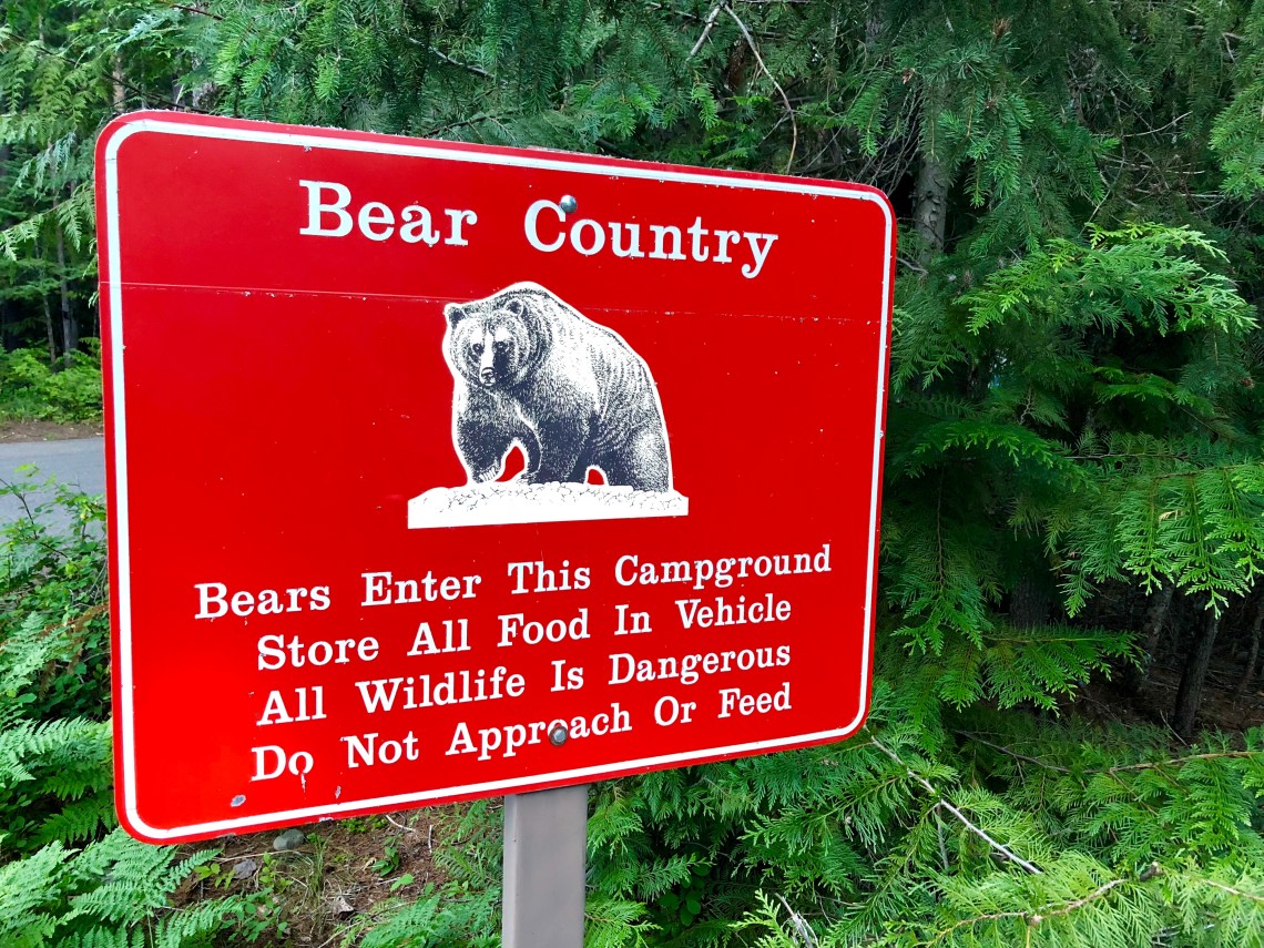
At 6,646 feet, Logan Pass is the highest point on Going-to-the-Sun Road. My senses on overload, I park and walk up to the Visitor Center, which I quickly learn is closed. Above the center, a large snow field stretches skyward to the foot of Reynolds Mountain. It is quite windy and cold at this elevation. Snow covers the trail leading into the meadow and I hike out as far as I can before quickly sinking into calve deep drifts. Keeping an eye out for grizzlies, which forage in high plateau meadows this time of year, I wander back to the van and into a brief conversation with a group of four adventurous souls.
Gathered behind an open Subaru tailgate, three guys and one young lady are adjusting their boots, ski and snowboard bindings. They are all smiles, loud with excitement.
“Hey, how’s it going?” Brilliant opening question.
“Good, man. What’s up my dude?” He’s wearing a kelly green baseball cap, a patchwork vest and lime green ski pants. “Are you the bearded one?”
“I am. Where are you guys heading all geared up?” Obviously there are no resorts or chairlifts in the park.
“Up there dude.” He points to Reynolds Mountain. “Hike to the top and glide down. Freestyling baby.” They all look at each other and start bobbing their heads. I’m reminded of the Al Kaline bobbing-head doll in my son’s room.
“That’s a long hike for a single run.” It is literally a few miles through deep snow.
“Fuckin’ worth it man. Fuckin’ worth it,.” says the man wearing shorts. Shorts. They are all lit up with smiles.
“I’m jealous man. Looks like a great time.” Part a is a small white lie. Part B is the truth.
“Slap on some boards bearded man.” He may have on shorts, but I believe he is dead serious. I catch a whiff of a sweet smell. I think these guys are pretty high.
“Next time. I’ll catch you guys next time.” One at a time they lean into the van and we shake hands.
“Take care, oh bearded one.” He adjusts his vest. They all turn and begin walking across the parking lot toward the snow. I watched until they became four specks at the base of the mountain.


After Logan Pass, the road begins a steady descent toward St. Mary. At Siyeh Bend the road loops around, surrounding mountains standing covered in snow, weighty, living. Several days earlier, Jackson Glacier marked the farthest point west on Going-to-the-Sun Road. I stop to get out for another look at the deep white saddled glacier. It had taken me well over 6 hours to drive the 50 miles of Going-to-the-Sun Road. There were several hikes along the road I wanted to take before heading along the western border of the park toward Bowman Lake where I was spending the night before heading south to Yellowstone in the morning. But before turning around and retracing Going-to-the-Sun Road in the opposite direction, I drove toward the trailhead of Saint Mary Falls. I hiked a short distance toward the falls, crossing a small stream, wishing for a simple twist of fate. I walked back to the van, sat and buried my face in my hands. Sometimes even Eden can’t blur the loss.