

Yosemite Valley, to me, is always a sunrise, a glitter of green and golden wonder in a vast edifice of stone and space – Ansel Adams
Sleep comes easily to me, but typically refuses to stay. I’ve been this way since I was a teenager and have long since given up on trying to change the pattern. On this night, 2:00 AM found me wide awake. A few minutes later I dressed and left Great Basin National Park in the middle of the night. Heading west out of Baker, Nevada, I find myself alone with the road and a full moon.
Lincoln Highway runs the width of central Nevada, methodically crossing some of the least populated counties in America. Bathed in eerie white, grand empty spaces spread out on either side of the road. Small ripples in the landscape normally hidden by darkness, stand in detailed relief. Watering holes reflect the moon, while horses graze in fields of alabaster. Storefront windows in Ely and Eureka pass – silent, moonlit. Snow covered peaks in Humboldt-Tolyabe National Forest, appear backlit, ridges of bright cotton clouds blurring the line between rock and sky. It is a glorious night and I want the sun to stay hidden behind me forever.
Lake Tahoe is about 20 miles west of Sparks, Nevada. Route 50 leads you along the eastern shore before dipping into California and Eldorado National Forest. Never forming a straight line for more than a few hundred yards, the road rises and falls with the landscape, ducking in and out of deep green clinging to the sea-like blue lake. South of Meyers, Route 89 begins meandering south, then east past snow topped Waterhouse Peak, before marrying Route 88 and Kit Carson Pass. Crossing the Sierra’s in spring is like a carnival ride in white. A rollercoaster ticking its way to the summit, before raising you out of your seat during a gut dropping descent. Never dull, never quite safe, but minus the carneys.

Deep snow closes Route 120, which runs directly through the park, until June or later, so entering Yosemite from the east is impossible. Route 88 being open is a testament to the determination of California road crews. Narrow, it’s like driving in a tunnel, snow inches from the road, dwarfing every vehicle. Tops of small conifers struggle to free themselves of heavy snow, their green needles looking skyward. High on the pass, Kirkwood Resort is surrounded by snow pack that clears the roofline. Caples and Silver Lake are blanketed in white. Water runs across the road, seeking a path down the mountain. Near the summit, I stop and record the sound of water rushing off the mountain.

Waiting at the foot of the Sierras, California’s central valley spreads out like a quilted blanket of of yellow and green, stitched in barbed wire. Mile after mile of gently rolling hills, veined with narrow man made furrows of water. Ranches stretch to the horizon, often dotted by a single tree and cattle of different colors. I turn on the radio and open the windows. The air is fresh and crisp. Don McLean is singing Vincent and I smile at the coincident of hearing one of my favorite songs at this precise moment. If this was a scene from a movie I would question the director’s audacity.
Starry, starry night
Flaming flowers that brightly blaze
Swirling clouds in violet haze
Reflect in Vincent’s eyes of china blue
Colors changing hue
Morning fields of amber grain
Weathered faces lined in pain
Are soothed beneath the artist’s loving hand
When Yosemite National Park was created in 1890, Hetch Hetchy Valley was as glorious as today’s Yosemite Valley. A resplendent U-shaped glacier carved valley, with towering cliffs and waterfalls cascading onto a serene valley floor, John Muir called it a “remarkably exact counterpart” to the now world-famous Yosemite Valley, 15 miles to its south. Hetch Hetchy was one of Earth’s most beautiful places and it was supposed to be protected “in perpetuity”.
In 1913, after a long drawn out legal battle that saw the Sierra Club, John Muir and over 200 editorial boards nationwide on one side and Woodrow Wilson, San Francisco and powerful lobbyists on the other, Wilson signed the Raker Act, permitting the city of San Francisco to build a dam in Yosemite National Park. Representing the only time in U. S. history where a single city was allowed to appropriate one of our national parks for its own exclusive use. Months after the act was signed into law, a heartsick John Muir died and the conservationist movement sprang to life in the United States. In 1923, the O’Shaughnessy Dam was completed on the Tuolumne River, flooding the entire valley under the Hetch Hetchy Reservoir. A once majestic valley was now a reservoir designed to deliver water 167 miles west to San Francisco.
Less than one percent of all visitors to Yosemite, visit Hetch Hetchy. I understand time constraints and driving north to Mather and Hetch Hetchy Road is like visiting another park. But to miss this valley once inhabited by American Indians, is to miss witnessing one of man’s greatest alterations of nature.
Hetch Hetchy Road traces the Tuolumne River northeast. Below lies the scarred face of Poopenaut Valley, devastated by wildfire in 2013. Starting in a remote canyon of Stanislaus National Forest, the ‘Rim Fire’ burned over 250,000 acres and threatened Yosemite before being controlled. Mile after mile of barren, fragile black trees stand waiting for new life to spring up around them. Ahead the descending road rises to a series of hair-pin turns before reaching its end and a small parking lot. A few hundred yards away, the 430 foot concrete arch-gravity O’Shaughnessy Dam, holds back 306 feet of water covering a valley that once rivaled Yosemite.

“The most strikingly picturesque rock in Hetch Hetchy Valley is a majestic pyramid over 2,000 feet in height which is called by the Indians ‘Kolana.’ It is the outermost of a group like the Cathedral Rocks of Yosemite and occupies the same relative position on the south wall.” – John Muir

Wapama Falls is a 5.5 mile out and back hike. After crossing the dam and passing through a short tunnel, the rocky, uneven trail follows the shoreline, always remaining at least 50 feet above the reservoir. In the distance, Kolana Rock towers 2,000 feet above the water. Spring runoff has created dozens of small waterfalls, spraying the trail, leaving smooth rock, shiny and slick. In places, bowls of granite are filled with water. A small snake moves slowly up and over an edge of a shallow pool. Taking a few steps backward, I watch it reverse course, silently returning to the clear water, blending with the iron brown bottom. Giving it wide birth, because snakes are evil, I kept my eyes on the ground for quite a while.
You can hear Wapama well before it comes fully into view. Plummeting 1,400 feet over granite cliffs, you can feel its power in your bones and muscle. In front of the falls, a small outcropping of rocks jut out over the water. I didn’t pass anyone on my hike, but there are three people at the falls. Two men – one who looks to be in his 50’s and the other in his 20’s, are taking selfies. I ask if they would like me to take a few of them.
“Yes. That would be great. Thank you,” says the youngest.
“Are you father and son?”
“Yep. It’s my dad’s birthday, so we came out here to celebrate,” says the son.
“Congratulations Dad! You’re a lucky man.”
“Thanks. I am,” the dad says, smiling at his son.
As a rainbow forms directly behind them, another scene that Hollywood would thankfully cut, I take several shots of father and son. The son then takes a few of me.
“Happy birthday….”
“Tom. My name is Tom and this is my son Stephen.”
“Smitty. Nice to meet you both. Be good to each other.”
They turned to look at each other, the spray coming off the falls getting all of us wet.
“Thanks Smitty. Be careful out there,” said Tom, before moving back up the trail.

Standing directly in the path of the waterfall’s heavy spray is a young man with a camera at his eye. I notice that after each click, he pushes a small lever at the top of the camera. This guy is shooting film! I wait until he back away from the falls.
“Hi.” I extend my hand. “Smitty.” We shake hands. “Are you using film?”
“Connor. I am.” He grins. “Don’t say it. I know.”
“No. I think it’s great. Courageous these days. Is it difficult to find film? To develop?”
“Not really. Everything is online. I ship out the film and get back hi-def negatives in about ten days. Not that expensive either.”
“Is it the thrill of opening the package? Is that what does it?”
“That’s certainly part of it. But I just like how film treats my subject. I get a truer image.”
“I love film as well. Used to shoot and develop my own once upon a time. But I’m not sure I could go back to film. I’m spoiled. Digital gives you so much flexibility.”
“You’re right of course, but for now I’m sticking to film.” He shrugs his shoulders and smiles.
“Good man. Keep film alive. Hey, let me get a shot of you with your camera. This backdrop is incredible.” He hands me his camera, takes a few steps back and smiles.

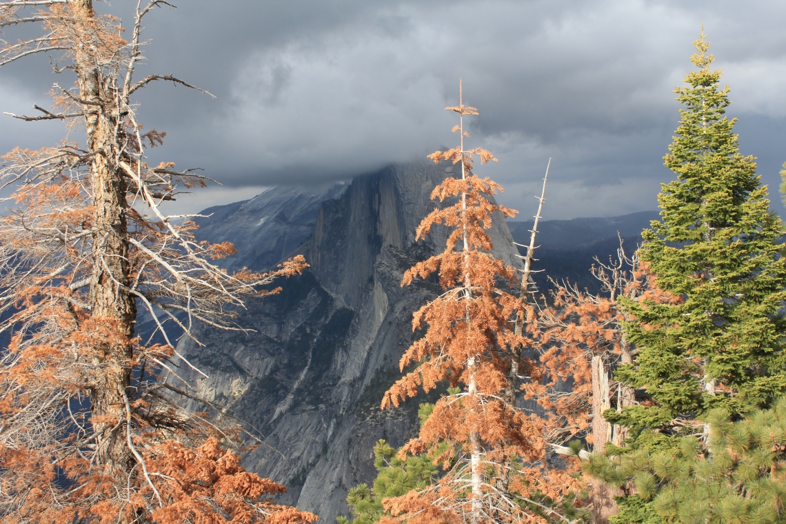
Glacier Point Road begins at the Chinquapin intersection on Wamona Road and winds steadily upward for 16 miles. Passing Yosemite Ski and Snowboard Area and Bridalveil Creek, the road hugs mountains on one side and opens to McGurk Meadow, thousands of feet below on the valley floor. At 7,450 feet, Washburn Point offers the first and loftiest views of Half Dome. But not on this day. Low clouds, deep grey and menacing, hang over the valley. I wait a while for the clouds to lift before heading to Glacier Point at 7,200 feet, where I find the same clouds. There are several people waiting for a clear view of Half Dome and the valley below. Every few minutes a break in the clouds appears and the crowd collectively sighs. It was a perfect day for dramatic photos, but not of Half Dome and the invisible valley floor. After about an hour I head back down beneath the clouds.
Note: Two days later I drove back to Glacier Point. The sky was perfect with clouds bouncing in and out of frame, the sun playing on the trees. I stayed for hours looking at the great granite dome above and the valley floor below. Cars moving along a thin line, ant-like in precision. The Ahwahnee Hotel a spec of brown in an ocean of granite and green.

For 99.99% of the population, there are two perspectives to Yosemite. Above and within. Above the valley from vantage points such as Glacier Point and Tunnel View. Or from the many meadows of the valley floor below. Then there is that .01% of the population that climbs the granite faces of Yosemite.
Before June 3, 2017, to simply contemplate what Alex Honnold did would be considered folly. It was something thought impossible. Certain death. Yet there he was on the face, completing the first-ever free solo of El Capitan. According to National Geographic, “He ascended the peak in 3 hours, 56 minutes, taking the final moderate pitch at a near run.” Most roped parties climb the 3,000-foot granite slab in 33 pitches over 3-5 days. What Honnold did was unthinkable. One of the greatest physical and psychological feats in history. As I stand near the base of El Capitan less than a year later, I am trying to intellectually process what he did. I can’t. It’s a feat from another world.

Hiking along the valley floor might be as close to a perfect hike as I’ve had yet. Flat the entire length of the valley, it wanders in and out of vast green meadows with a hint of wildflowers. Each turn presents unhindered views of waterfalls and looming granite against a bright blue sky. The Merced River flows between the valley’s single loop road, with gently sloping banks creating comfortable places to sit and listen to the heavy spring water rush over rock and mid-stream islands. A lone mule deer wades out into the river, finds a small piece of land and lazily begins to graze. As hours drift by, the sun plays on granite walls, a descending slideshow of shifting dark colors. Tired, I lay down in a field of tall grass, my backpack for a pillow. When I wake up, it’s cold, the ground is damp and the stars are dancing. Cue the soundtrack to La La Land and I will dance along with the stars.


I asked a ranger when Tioga Road was opening. “In two days,” he said.
“Two days?” I was floored. When I first arrived at the park I was told it would be at least several weeks.
“Two days,” he repeated.
Tioga Road, derived from an Iroquois and Mohawk term meaning “where it forks”, runs from Big Oak Flat Road and Crane Flat in the west, to an elevation of 9,943 feet at Tioga Pass Entrance in the east, before continuing on to Lee Vining Pass and salt water Mono Lake. Thirty-nine miles of countless turns through high meadows and lakes, bluish granite domes, tufa towers and mountain peaks. As I turn onto Tioga and begin to climb, the skies are perfectly blue, with a few lonely clouds languidly drifting.
Listed on dangerousroads.org, because of “unpredictable snowstorms and blizzards”, traveling Tioga this early in the season holds a few surprises. Near Tenaya Lake, banks of fog silently roll across the road and I am forced to pull off and wait on a narrow shoulder. Higher, hiking near Tuolumne Meadows, large snowflakes fall, covering small patches of yellowed grass. About a hundred years away, two small boys are having a snowball fight. Snow collects on my heavy wool sweater as I hike back to the van. I need to get below the weather, so I slowly start down Tioga.
With multiple stops for photos and some exploring, the trip up Tioga took roughly 3 hours. The 39 miles down, without stops for photos or exploring, took roughly the same. At one point I sat for over 30 minutes until the snow let up enough to see. A firm reminder that winter hadn’t quite given up on Yosemite. Further down, fog played in and out of peaks, settling in Tenaya Canyon directly to my left. Scenes I photographed only hours earlier had disappeared. Olmstead Point passed invisible from the road. Then, as if by magic, the fog vanishes. Lower still, peeks of blue sky. I roll down the window and the air is warm. As I turn south on Wawona Road and head back to camp, I feel as if I’ve wandered in and out of the twilight zone.


Wawona Tunnel was bored through solid granite bedrock, carrying Wawona Road through a granite mountain on the south side of the Merced River. At 4,233 feet, Wawona Tunnel is the longest highway tunnel in California. It also leads to one of the most majestic views in America.
Tunnel View looks straight down the length of Yosemite Valley. Made famous by Ansel Adams, it is one of the most photographed spots in the National Park system. El Capitan quietly shoulders one side of the valley, while Bridalveil Falls, a movement in white, drops over 600 feet from one of Yosemite’s glacier carved hanging valleys. Half Dome rises sharped edged, lurking at the valley’s end. A forest of black oak, ponderosa pine, incense-cedar and white fir dominate the foreground, perfect in contrast. As shadows play on light and dark granite, the valley feels in motion, revolving in silence. I am reminded of a hand colored photo of Eden. The frontispiece in one of my father’s worn leather books from childhood.


I ll definitely do a trip to Hetch Hetchy my next trip to Yosemite. Great story on the history. Stay well!
LikeLike
Thanks for looking in Micheal. I appreciate the kind words. Please give your family my best.
LikeLike