
When you’ve climbed the highest mountain
When a cloud holds the sunshine in
Suddenly there’s a valley
Where the earth knows peace with man – The Drifters
It’s late afternoon when the glass, dazzle and hum of Las Vegas disappear to the south. Ahead, a series of vast basins extend from California’s Sierra’s in the west, to the Wasatch in the east. From southern Nevada, north into Oregon. A chain of great valleys where rivers flow inward, never reaching the ocean. I merge onto Route 93, which runs north through their heart.
Between Las Vegas and Great Basin National Park, a distance of 300 miles, the valley spreads out and rarely contracts. Passing through the one blink towns of Coyote Springs and Alamo, Nevada, Route 93 is a straight, singular strip of brown-black concrete. Today, blue-tipped suede mountains prop up a dull white sky. Charcoal colored rain falls in curtains from black clouds hovering just above the ground. For hours storms gather to the west and teasingly pass to the north. The road is empty and mine. Never touching me, yet perfectly on display, sinister clouds, rain and wind are a performance for one. I have the only ticket and the director is well aware of her audience.

North of Major’s Place, the road slowly makes a half circle, turning west, then loping east before joining Route 50. Ahead, a massive wind farm rises up, splayed white arms imperceptibly turning. Stretching for miles, row upon row of winged giants standing in stark contrast to the scraggly ye
llow sage on which they rest and dark mountains over which their strength flows. Across the road cattle graze, while men on horseback ride to the furthest reaches of their farm to gather a lost calf. The future and a lifestyle as old as our country, dovetail along a stretch of remote Nevada road.

Passing through the small idling town of Baker, Route 487 t-bones Route 488 which then heads due west, gently rising almost 1,500 feet before entering Great Basin National Park. Wheeler Peak stares down from its snow covered roost. Along the road, various pieces of primitive art have been attached to fence posts. A scarecrow by the name of Bob Wire. A large wooden rabbit, chipped and weather beaten, holding a bit of straw in its mouth. Other works so abstract as to defy description. Someone has put a lot of time and effort into this gallery and I am the overjoyed beneficiary.

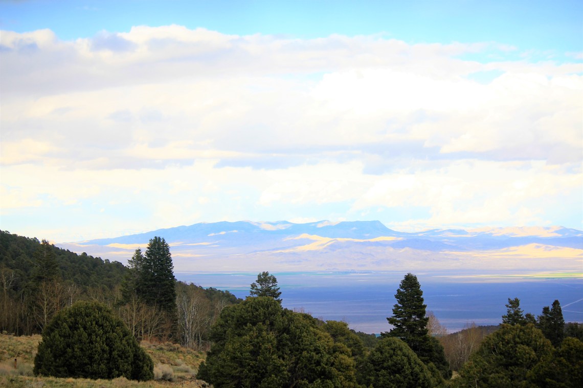
Near the top of the incline, the road gently curves south. Snake Valley and the Snake Range lay at your feet. Driving for many hours through the valley, my perspective was from the ground up. At an elevated vantage point, the scale of the valley becomes clear. Running north-south, it sweeps across the landscape uninterrupted, horizon to horizon. Greens of rich farmland, hand-tied to man made blue water. Colors sewn together like an old blanket.
Wheeler Peak is the second highest mountain in Nevada, summiting at 13,063′. Part of the Snake Range that dominates the western half of the park, it towers over its lesser neighbors, Baker Peak, Bald Mountain and Jeff Davis Peak. I am here after a winter where, until recently, snowfall has been light. Then March roared, making up for many of the previous dry months. As a result, the road to Wheeler Peak is closed at Upper Lehman Campground. Deep snow and ice make the road unpassable. To get to Wheeler Peak, I would have to walk 4 miles in knee-high snow, while gaining over 5,000′ in elevation. To say I considered it for more than a nanosecond would be a stretch. The fact that I actually considered it after hiking in snow at Rocky Mountain National Park earlier in the month, should provide you with keen insight into my decision making process. I’ve been told it’s not pretty.
Lower Lehman Campground sits at 7,300′ and is home to only 11 sites. Passing a small gleaming Airstream, the only other camper, I tuck into a spot at the end of the paved loop. When I get out to stretch and explore the area, it’s chilly, but not cold. Walking a hundred feet or so, back along the paved loop, a small trail appears. Within a few yards a view of the Snake Valley opens. The sun is low in the sky behind stray clouds. Golden sunlight lays in broken strands across the valley, shapes mimicking the clouds. Where the sun is absent, the valley floor remains a bruised lavender. Mountains, draped with yellow clouds, glow Egyptian blue. I am looking at a panorama of colors on fire, lit by the sun. Several minutes pass before I turn and walk back to the van, pulling out the two burner to begin dinner. If someone had asked me my name at that moment I would have stumbled.

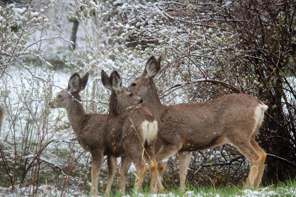
When I wake up, the windows are covered with snow. I step outside to a different world than the one I last glimpsed before closing my eyes. Brown and yellow sage has been replaced by bright white, with green grass managing to poke through. Rocks in the small stream running behind my site are flecked with large snowflakes. Snow covers logs and weighs down branches. As I walk toward the bathroom, snow accumulates on my head and the shoulders of my jacket. As I round a small curve in the road, several mule deer quickly raise their heads. Snow has gathered and melted on their backs, making their fur shine. I stop, raise my camera and begin to shoot. They stand like statues for a few moments, posing, before slowly, deliberately moving into the brush.
Since I can’t be in each park at precisely the right time of year, when all roads are open and every trail accessible, there have been a few sites that I’ve missed. Fortunately, so far, those have been few. However, Great Basin is home to a rare piece of nature that I would have loved to see. High up in the Snake Range, between 9,500 and 11,000 feet, bristlecone pines have watched time slip by for over 3,000 years. Growing slowly, sometimes a single branch at a time, with needles that can last 40 years, bristlecone pines stand on gnarled, naked trucks. With wood resin that prevents rot, they age with artistry, witnessing the methodical passing of time from their lofty home. I really wanted to see and touch a bristlecone pine. Next visit. My guess is they’ll still be there.
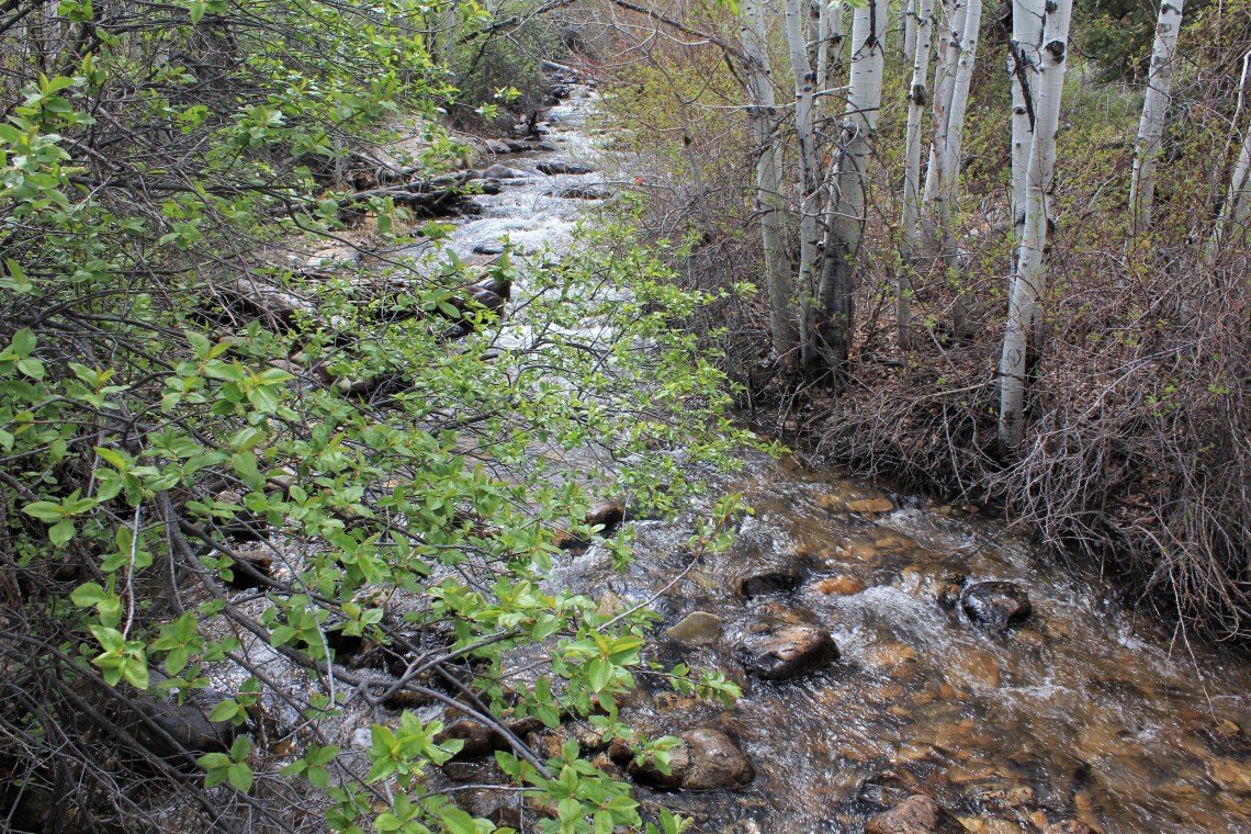
Baker Creek trailhead sits huddled in a small indentation at the end of a short descending road, next to Grey Cliffs Campground. At 7,000′, the roads and trails in this remote section of the park are mostly free of snow. As the day warmed, much of the new snow has melted and temperatures hover around 50 degrees. Perfect hiking weather. I step onto the well worn trail and begin walking through clumps of pine and aspen. Several slippery foot-bridges cross the creek, which follows alongside the trail for some time. Runoff from the mountains give the creek depth and sound. A soothing backdrop to a still forest.
To my left grey cliffs form a wall, towering above the trees. Pine trees line the lip, reminding me of a stiff brush cut. At points along the trail, openings into small meadows appear. The grass is green and broken trees lay along the edge of the field. More mule deer come to attention, large fuzzy ears standing straight up, before lowering their heads in search of food. I walk within a few yards of the group and they are unfazed. I can hear them chewing.

During the course of this journey, I have been the beneficiary of many things. Not the least of which has my luck with the heavens. Thousands upon thousands of miles driven. Hundreds of miles hiked and countless photographs taken. Through it all I can count on one hand the number of days when I’ve encountered a white sky. A sky absent detail. To a photographer, at least speaking for myself, clouds and rumpled skies are my best friend. They lend drama and context. Flirting with shade and dimension, they are timeless and can be shot in black and white as easily as color. Blue becomes bluer, leaden skies less grey. So a toast to my friends, the weightless drifters, bringing life to heaven and earth. May you forever follow my path.


Truly beautiful!! I love reading the stories of your travels Larry!
LikeLike