
I rose early, before stars passed into daylight and a yellow, waxing moon dropped behind Furnace Creek in the west. Passing through Death Valley Junction, the distant horizon began to slowly change. Grey gave way to a thin red line, stretching north and south. Behind me, flickering stars faded, diminished until their dusk revival. Ahead, the Amargosa Opera House stood alabaster white in full low sun, her Caribbean blue letters standing deep in stark contrast. Route 95 rolled through looming sandstone formations, rising and falling with the terrain until Las Vegas sprang from the desert, a gleaming aberration. A city of glass, surrounded by desert, mountains and a reflecting sky.
Jerry Seinfeld at Caesars Palace. The Righteous Brothers with Bill Medley & Bucky Heard at Harrah’s. The Rat Pack Is Back at The Copa Room! My eyes, so accustomed to the simplicity of nature, jumped from one billboard to another. My brain, tuned to a park’s stillness, suddenly erupted. Ten lanes of snarled traffic, funneled past casinos, gentlemen’s clubs and the ever present In and Out Burger. Head-shots of every injury lawyer and real estate agent in Las Vegas, smiled down into the cement canyon, begging trust. Magicians threatened to make an elephant disappear, as exits speared into the shimmering. Then, as quickly as they had risen from the desert, the towering glass boxes gave way to terracotta roofs and neatly lined streets. Billboards slowly surrendered to dusty roadside slopes and newly planted palms. Fifteen minutes later I began to think that I may have simply dreamed of a city of glass.

Heading steadily northeast, I-15 briefly finds its way into Arizona and the southern edge of one of the most expensive stretches of interstate highway ever constructed. The Virgin River Gorge, carved over thousands of years by the Virgin River, winds its way from the small town of Beaver Dam, Arizona to St. George, Utah, connecting the southwestern rim of the Colorado Plateau and the Mojave Desert. Five hundred foot limestone cliffs border the highway, as it runs through the canyon and crosses the river several times. Cars and trucks are buffeted by the unseen hand of the wind snaking through the canyon, moving along the steep walls. Forty five miles to the northeast, the river rises on the Colorado Plateau, creating the stunning topography of one of America’s most beloved National Parks.
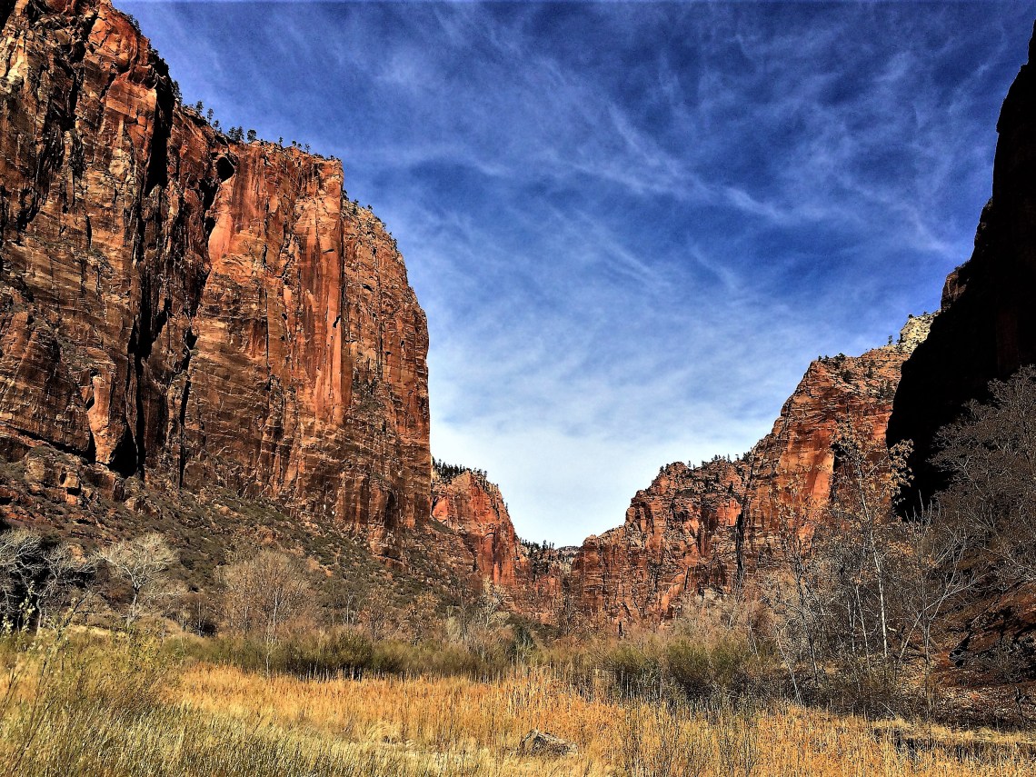
Each National Park has a unique innate beauty. Each provide natural and man-made pathways to explore the wonders they contain. Shenandoah has a road that runs her length, an elevated spine that allows us to look down and into her beauty. Everglades lay open to exploration, the vast flat sea of grass enveloping you. Sequoia’s roads and trails lead you into her sprawling forests, yielding glimpses of her distant majestic peaks. Zion National Park lures you into her heart along a narrow road leading to The Temple of Sinawava. She places in you a sense of awe from the moment you enter her gates and are forced to gaze skyward. Up to the heavenly peak of The Watchman.
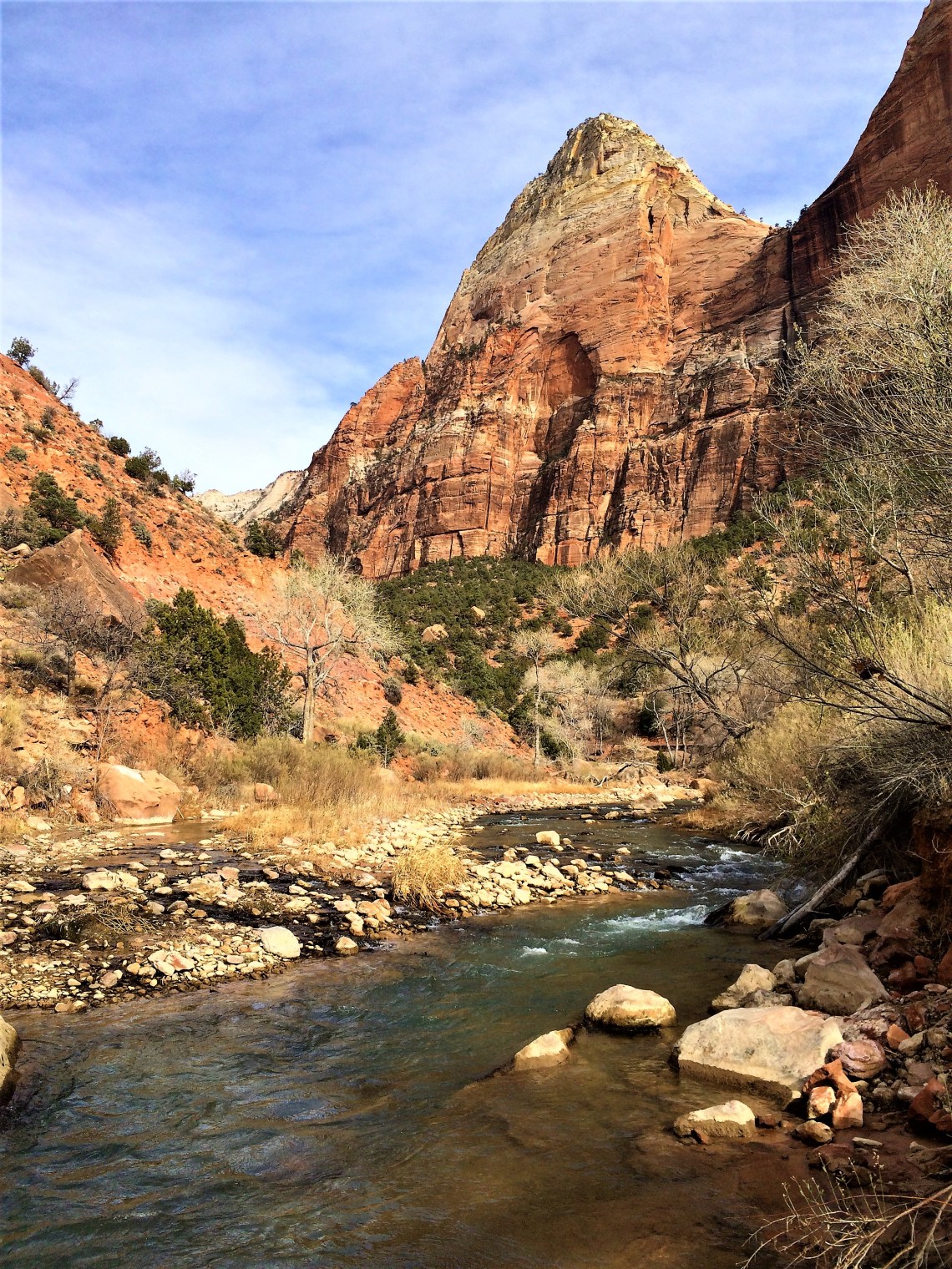
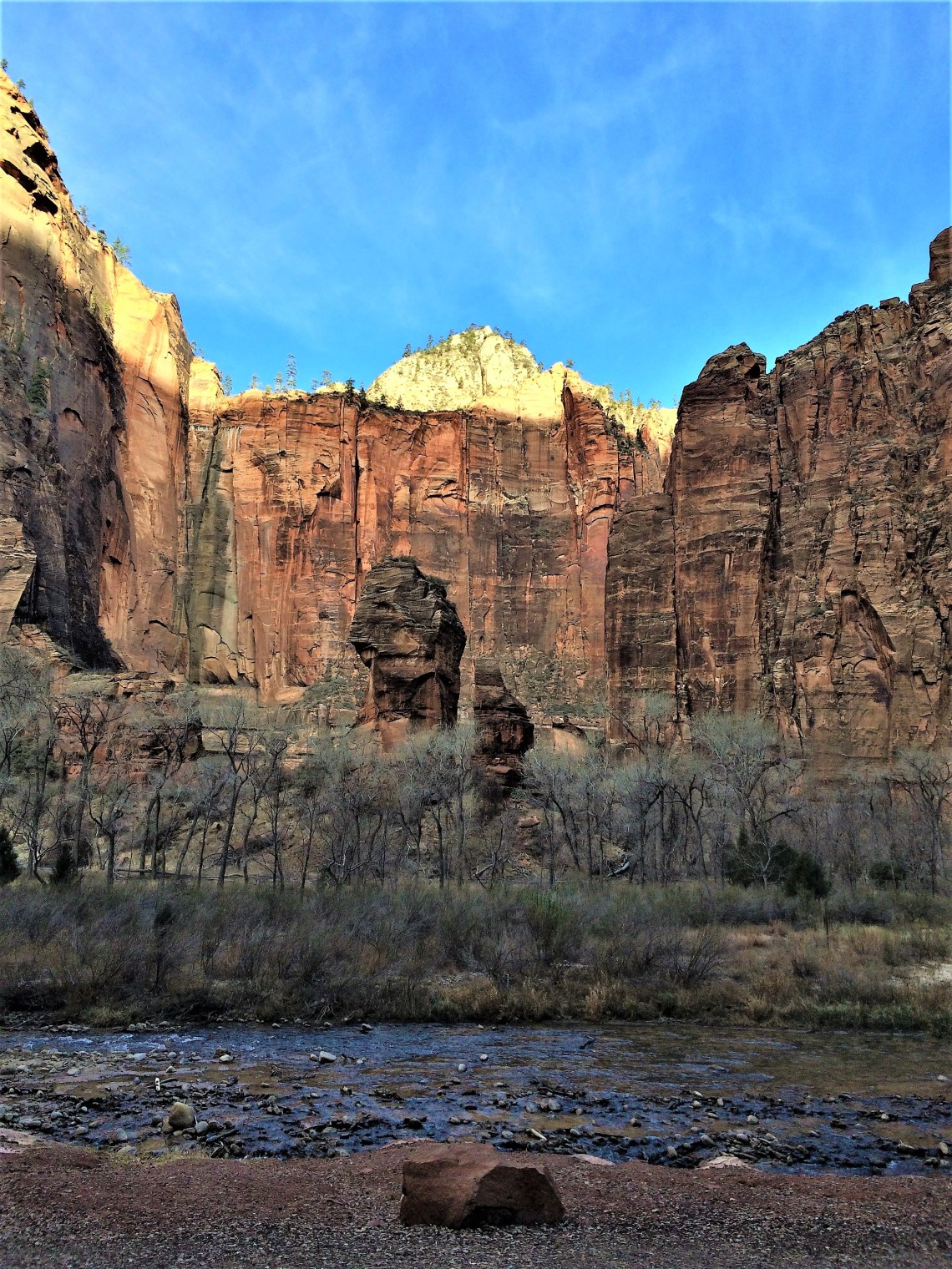
Although a single park, Zion is three distinctly different experiences. To the south, the 6.6 mile Zion Canyon Scenic Drive winds through 2,000 to 3,000 foot canyon walls. Barely a half mile wide, the deep V carved by the north fork of the Virgin River intersects with Pine Creek, flowing down from the elevated mesa to the east. The Three Patriarchs, black streaked Navajo sandstone, imperiously guard the canyon’s western flank. To the east, The Great White Throne rises 2,500 feet from the ever churning river, blocking the morning sun. Zion Lodge rests in her shade, nestled in a grove of Freemont cottonwoods. In the early morning hours, as the sun fought to warm the valley, I sat on the porch and listened to the sound of woodpeckers and the distant murmur of the river.
The trail to Upper Emerald Pools begins easily enough and leads past some breathtaking views of sheer face cliffs. Descending into willows, their rock visually softened, the sandstone glows orange in the sun. A small herd of mule deer search for food below and pay little attention as I move along the path above. There are three levels to The Emerald Pools and I reach the lower pool in about thirty minutes. Fed by upper streams and dropped from an overhanging cliff, the pool sits below the path, bordered by large boulders and smatterings of perfectly white snow. The trail leads directly under the runoff, a steady parade of large droplets. Caught in the morning sun, they seem to hang in midair before falling. The sound of each singular drop melds together, creating the auditory illusion of a stream. I climb to a vantage point off to the side of the pool and listen to the watery chorus.

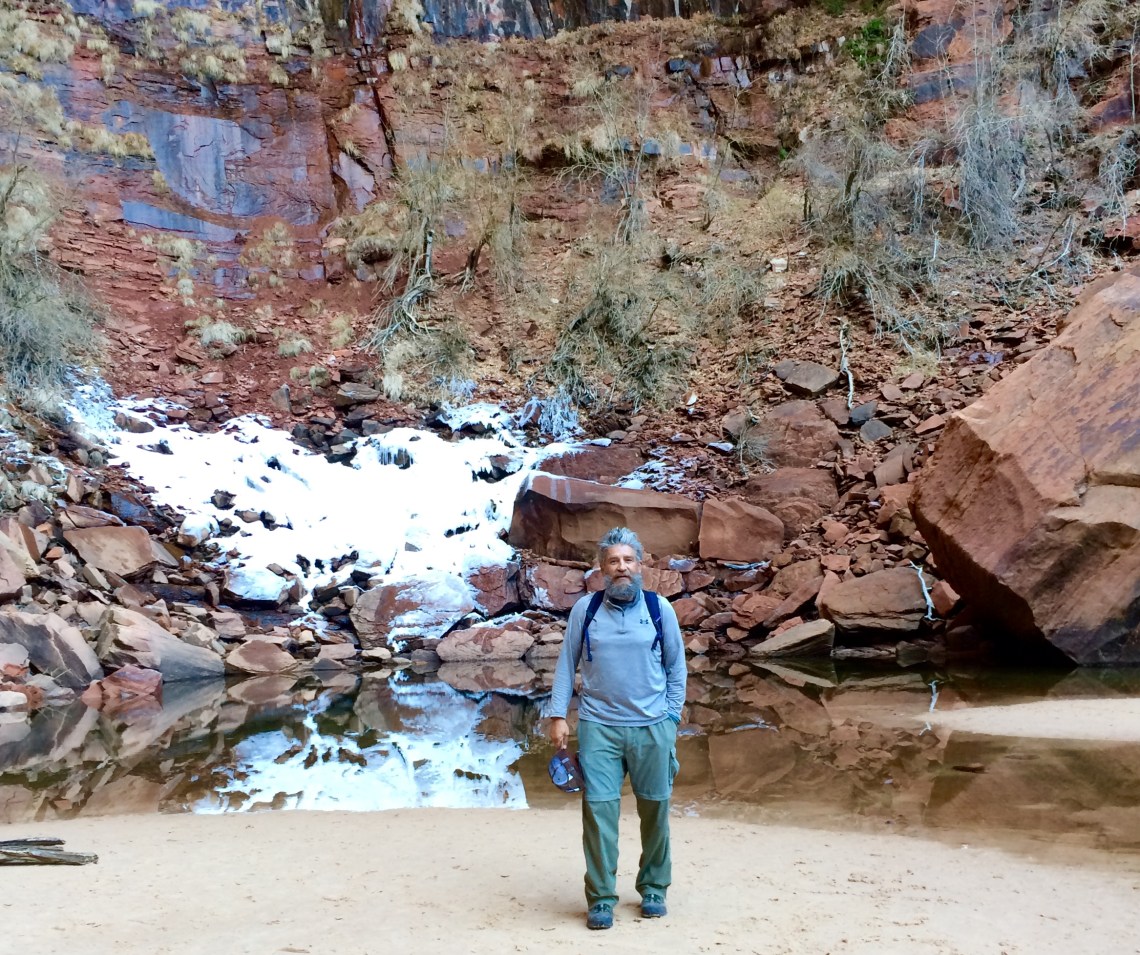
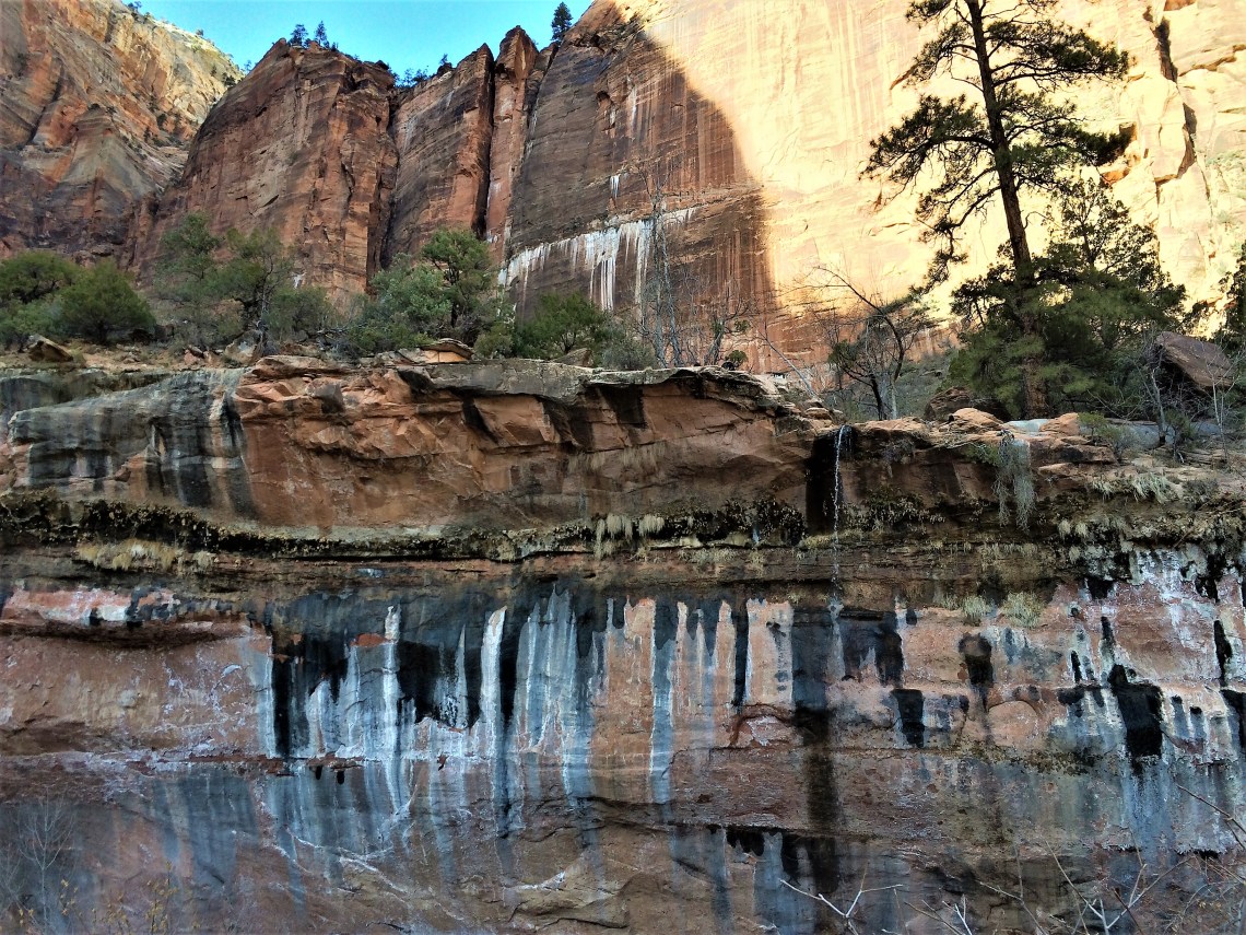
To reach the Upper Emerald Pools you have to climb a rather steep sandy path that continuously curves through boulders, in and around patches of trees and brush. Near the end, in sight of the pool, there is one last boulder scramble. Finally, I find myself standing on a small spit of sand – a beach? – at the base of a multi-colored cliff, surrounded by Bigtooth maples. In front of me, a small clear pool spreads out from the cliff, creeping onto the light brown sand. Ice covers much of the rock where the water from above meets the earth below. Small ripples, perfect in their symmetry, reach toward the sand in unbroken arcs. It is cold and I wonder if sun ever reaches this small oasis. I sat beneath a maple, rubbing my arms and legs for warmth before heading back down.
Kolb Canyons occupies the far northwest corner of Zion. There are no roads inside the park connecting Kolb Canyons and Zion Canyon. To reach Kolb from the south you have to exit the park on Route 9, drive west along the Virgin River until the road intersects with I-15 heading north. Passing Hurricane Cliffs, which form the western boundary of the park, you re-enter the park on Kolb Canyon Road. Immediately you are wound into Taylor Creek Canyon, welcomed by the rugged face of Tucupit Point. As you move further into the canyon, mirroring the south fork of Taylor Creek and crossing Lee Pass, the landscape takes on a dramatic cowboy movie quality. Red flecked sandstone cliffs shoot 2,000 feet into the cloudless blue sky above Finger Canyons. In the distance, narrow grooves slice into Timber Top Mountain. An evening sun played down on the canyon walls, shadows falling across rock creating black pockets, details in relief. I watched as the sun set behind Hurricane Cliffs in the east before hiking back to the trailhead and driving south.
The town of Springdale borders Zion National Park at its southern entrance. It is a small town, with a small town feel. Shops, hotels, outfitters and restaurants line the road leading into the park. During my visit the town’s normal tranquility was broken by construction crews. Main street was being ripped up and replaced. Large trucks filled with cement and dirt roamed the streets, kicking up dust in this driest of winters. Two way traffic ceased to exist and waits to proceed in one direction could be as long as thirty minutes. It was a mess that closed businesses and stifled others. In my case, it made getting to the library more difficult.
Every two or tree weeks, I have to ‘sit down’ in a town and write. (I’m writing this piece in Bradenton, Florida, overlooking the Manatee River which empties into the Gulf of Mexico.) Springdale was perfect place to write. I knew I had five Utah parks ahead of me before heading to Florida to watch my son play baseball. I needed to write pieces on Death Valley, Sequoia and Kings Canyon. So for five days, I didn’t hike, I just wrote. I was at the library when it opened and left when it closed. During those five days I met some of the wonderful people of Springdale. I was invited to book club and enjoyed it immensely. (Thanks Miss Jewel and Jeff for the invite. Please tell Dan I’m still baffled by the concept of no absolute truths.) I was invited to movie night – Groundhog Day – and ate most of their popcorn. I was also graciously invited to return to Springdale on Earth Day and speak about TheMountCo Project. Many people offered their apology for the construction, while telling me how the improvements were needed and would vastly improve their town. Few complained. I greatly enjoyed my time in Springdale and can’t thank everyone enough for extending unconditional warmth, hospitality and popcorn, to a pretty ragged looking bearded man.
Canyon Overlook Trail begins at the eastern entrance to the Zion-Mt. Carmel Tunnel, a 1.1 mile hole cut through sheer rock at an elevation of 5,000+ feet. The hiking guide cautions, “long drop-offs”, “rocky and uneven terrain” and “not recommended for those with a fear of heights.” Check, check, check. All the things I love. Hugging the side of a steep cliff, the narrow trail begins moving upward with steps long ago sunk into the ground and a hand rail to keep you from dipping over the edge. Soon the steps and handrail disappear and the “rocky and uneven terrain” becomes evident. Somewhere around the halfway point, you have to cross about a 20 foot span on a set of wooden boards that hang out over the gorge, held in place by a few iron rods driven into the rock. It’s a short span, but I watch as people balk before crossing, or turning around. My thought is you either trust the iron bars or you don’t. I trust them completely. Walking out onto the wooden boards, I pause for a while to take in the view. To my left is one of the blasting holes used an an entry drilling point for the Zion-Mt. Carmel Tunnel. From here it looks small. A dark spec on the side of a deep brown face. Directly in front of me, several hundred feet below, winding narrow gouges open to darkness. Their depths unknown from above.

At several points, the trail narrows and pushes you against the sandstone wall. If you lean a bit too far the other way, you risk sliding down the boulder and tree lined slope. If someone is coming down the trail you wait and let them pass. Descending hikers always have the right of way. The trail levels off near the top and when you first step out into the open, the view is breathtaking. Stretching down from the north, the canyon floor sits guarded on all sides by giant rock formations. I scramble up a series of layered rocks to get a better vantage point. The wind is howling and there is nothing between the end of the rock and the valley floor except a thousand feet of open air. The sun is falling down, leaving a bright haze over the northern end of the canyon. I step back, hook my feet into a thin crevice for stability and begin to take photos. After a while I sit and listen to the wind. There are no other sounds up here. Just me and the wind, as the sun drew colorful shapes across the mineral layered rock.

Heading east from where Zion Scenic Drive meets Route 9, Zion – Mt. Carmel Highway, the steep road climbs the switchbacks of Pine Creek Canyon, passing the 400 foot Great Arch, sunken into the face of a burnt yellow cliff. Near the top, before entering the tunnel leading to Checkerboard Mesa and the Park’s east entrance, pine flecked Three Patriarchs loom in the distance. Below, the serpentine road, a length of ribbon carelessly dropped to the floor. Passing through the tunnel, original blast holes from 1929 toss an odd shaped beam of light across the road. In places the textured, black lined face of perpendicular rock almost blots out the sun, leaving only a cold sliver of light on the inside wall. I drove through the tunnel several times during my visit to Zion and in each case turned off my lights for a moment to experience total darkness. I can’t help it. I’m 16 at heart.

Exiting the tunnel onto a high mesa, the park takes on a completely different feel. Gone is the canyon and sheer rock faces that force your eyes skyward. Gone is the depth of the V shaped gorge. Suddenly the landscape has fewer dimensions. Dried creek beds wind through weathered sandstone etched into checkerboard patterns. Pinyon pines emerge from sandstone cracks and randomly dot the land. Open land begins to spread out, mimicking the narrow ocher and hazel green Zion Canyon floor, on a scale unobtainable only a few miles below. As I exit Zion, the two lane road lies straight, flat but rising, high mesa spread into the distance.


NOTE: For more information on Zion National Park and all the National Parks and to help with trip planning, download the free Chimani app to your smart phone to easily navigate your way around the park, with or without cell phone service.

Your photos and story are amazing. I like your blog. I’m going to share this on my blog!
LikeLike