

Writing has laws of perspective, of light and shade just as painting does, or music. If you are born knowing them, fine. If not, learn them. Then rearrange the rules to suit yourself – Truman Capote\
After a restless night, I was up before the sun. Through a clearing in the pines, the Rockies stood bathed in moonlight, back-lit by a million stars. As the night sky began to turn dusty grey, the mountain snow shone brilliantly white. Streaks of rose played between the shouldered slopes of evergreen as I headed south on Route 36. Passing Boulder and Golden, a silhouette of Denver lies to the east, before Route 275 begins its meandering path through some of Colorado’s most beautiful landscapes.
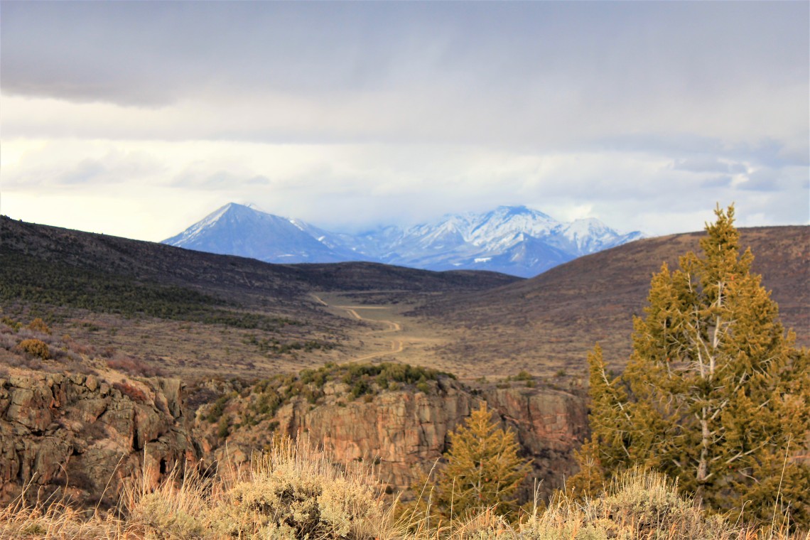
To my right, the road hugs an eastern edge of the curving Rockies, while miles of flat amber and snow covered farmland stretch to the horizon on my left. As the road curls around North Twin Cone Peak, a great high plateau valley appears. One in a chain stretching from Mexico to Steamboat Springs, Colorado, formed from stretching in the earth’s crust millions of years ago. With 15 peaks above 14,000 feet, the 100 mile Sawatch Range effortlessly appears as the road rises, dwarfing the rounded foothills that appear as an artist’s smudge. Each turn presents a scene worthy of Ansel Adams or Thomas Moran. Golden bales of rolled hay sit drying in great stacks behind thin wire fences. Cows, oblivious to their surroundings, pace the land on which they were born. Further south, Buffalo Creek Reservoir sits cradled below Buffalo Peak, patiently waiting for spring and fresh water from Pony Creek.

Pancha Springs rests 7,464 feet above sea level, just west of the Arkansas River. Twenty minutes later, Monarch Pass rises to an elevation of 11,312 feet. Twisting ever upward at an 18 wheel humbling grade, Route 50 cuts a path through aspen forests and summits near Monarch Mountain, before reversing grade and dropping down to Dry Gulch and Tomichi Creek. Ahead lies the sprawling Blue Mesa Reservoir holding Gunnison River. Glimpses of a dark canyon wall appear as the road ventures close to the river. Here the road is cut into brown stone, sharp edges tinged with snow that haven’t seen the sun. Suddenly the river veers north and the road levels across farmland before intersecting with Route 347.
As the road climbs, the San Juan Mountains dominate the southern horizon behind me. A vast plain and the town of Montrose appear to the west. Proud ranches dot the roadside, ornate entryways announcing their namesake. Several mule deer stand in a field of sagebrush and pinyon juniper. Nothing hints at what lies a few short miles ahead. A canyon of sheer black walls that drop 2,722 feet from edge to the Gunnison River. There is no hint that a canyon cut by water, who’s course was determined millions of years ago, lies less than 100 yards from the edge of the road.
Rim Rock Trail leads from South Rim Campground, my home for a few days, to the South Rim Visitor Center. An orange colored, well worn path running just beneath the lip of the canyon, it wanders through Gambel oak and sagebrush. Gnarled junipers, each a woodworking piece of art, are undercut by waist high pinion junipers, grabbing at my clothes. There are no railings along the trail, with numerous opportunities to carefully approach the edge of what I quickly realize is about a 2,000 foot drop. I climb down a series of rocks and get my first unencumbered look straight down into the canyon and its creator. It’s breathtaking and just a bit intimidating.
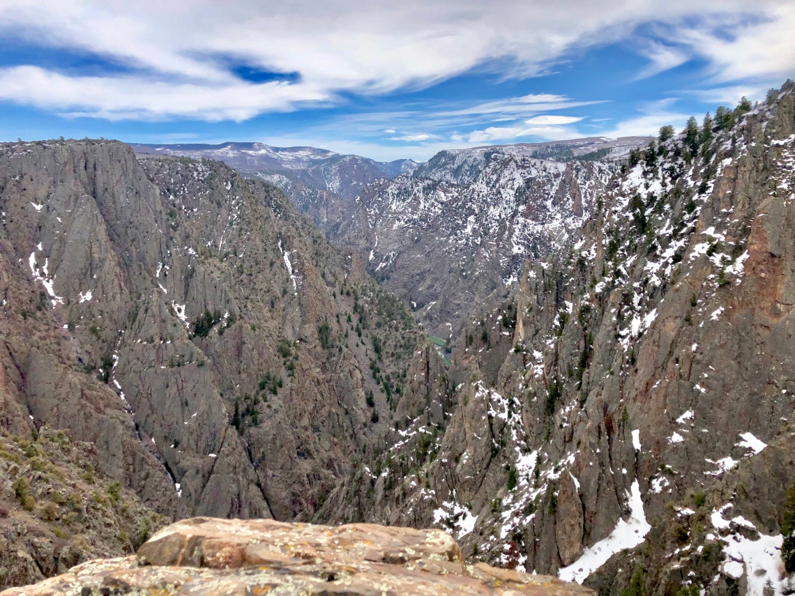
Black Canyon of the Gunnison is the length of Manhattan and taller than two Empire State Buildings placed on top of each other. It has been the Gunnison River’s life’s work, encompassing over two million years of tediously, relentlessly chisling its way through dark grey metamorphic rock. To quote geologist Wallace Hansen, “Some are longer, some are deeper, some are narrower, and a few have walls as steep. But no other canyon in North America combines the depth, narrowness, sheerness and somber countenance of the Black Canyon of the Gunnison.” After spending a few days with her, it’s the ‘somber countenance’ that stays with me.
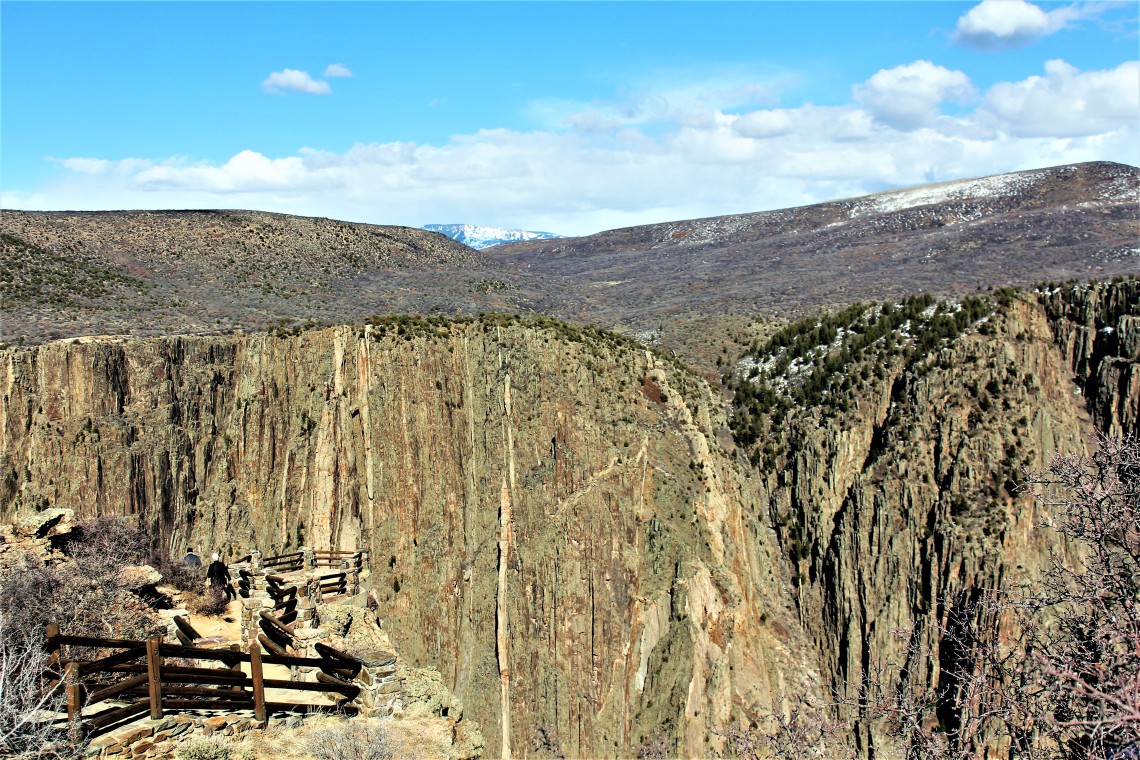
There are no bridges across the canyon and a single road runs through the park on the south side. South Rim Drive is 7 miles from Tomichi Point, dead ends at High Point, and has 12 overlooks along the way. Gunnison Point, Chasm View, Painted Wall and Sunset View provide the best views into the canyon. All are reached by relatively short trails which typically dead end at a small observation platform of rock and a semi-circle of railing. The National Park Service has concluded that we are all smart enough to stay behind the waist high railing. Intelligence, however, can take many forms. I’m also told that lack of intelligence is readily apparent.

Painted Wall is on the north side of the canyon. The overlook that bears its name stands directly across from the 2,250 sheer cliff striped in every shade of grey. Decorated with striking pink and white crystalline pegmatite, an extrusion of magma that seeped into cracks in the rock and hardened, the wall would hold its own against any work of Jackson Pollock. Bob Ross might be pushing it.
With a straight face, the ranger told me to look for mountain lion tracks when I hiked to Warner Point. “And what should I do if I see any?” I asked.
“Nothing. Chances are virtually zero. Typically mountain lions are very reclusive and we haven’t had any reported sightings in quite some time. Just let us know if you see any tracks when you pass by the station. Do you know what a mountain lion’s print looks like?”
“Yes.” Pause. “So virtually zero? Not zero? And could you define quite some time.”
“Let’s just say zero and a few years. Have a great hike. You are going to love Warner Point. Best views in the park. Oh yeah. Keep an eye out for elk, bear and bobcat tracks as well.” He literally turns and exits.
“Thanks. I’ll report back if I see any tracks,” I say to the back of his uniform. With that rousing bit of encouragement ringing in my ears, I drove to the end of South Rim Road, parked at High Point and found the snow covered trailhead.
At this point in my travels, with the exception of a wonderful hike with Keith and Kim in Kentucky and a group of friends on Cape Breton Island (Peg, Dunc, Connie, Gary, Mike Amy, Marie and Little Marie) all of my hiking has been solo. Today was no exception, so the thought of running into a mountain lion, no matter how remote the possibility, kept my head on a swivel. At least I could scream before he pounced and perhaps he would take pity on me. If not, I mean if he really wanted to tangle with Mr. Smith, Mr. Mountain Lion was in for a tussle. I carry my dad’s old Case knife he used to whittle with and thanks to Mr. Ranger, I kept my hand in my pocket, on the blade. I’m writing this so apparently Mr. Mountain Lion was busy that day. Lucky for him. I would have whittled him a new set of whiskers. Authors Note to Reader: One must at least keep up the appearance of bravery.
The relatively flat trail vacillated between calf deep snow, mud and slush. Mountain mahogany, Douglas fir and juniper were plentiful, with Fendler bush, mule’s ear and scarlet gilia scattered below. The wind was constant as was the chirping of Canyon wrens, which flittered in and out of trees. Openings in the vegetation teased at what was waiting at Warner’s Point. Occasionally I could squeeze through a small opening in the brush, look down into the canyon and the looming San Juan Mountain Range to the south. As I reached the end of the trail and the 2,600 foot drop to the determined green river, skies turned a deep blue, brushing black. I could trace the grey rain as it fell across the sprawling Uncompahgre Valley and the West Elk Mountains to the north. I sat down with my back against an ageless spiraled juniper and watched the storm roll across the canyon.

Moving at its own pace, the storm slowly slid to the east, edging close to my side of the canyon but never reaching directly overhead. Already chilly temperatures dropped, as the rain morphed into large snowflakes. Wind turned vertical into horizontal, with snow turning the opposite side of the canyon into gauzy white. Snow began to gather on the pines that dotted the inside of the canyon walls. The San Juan Mountains hid behind a wall of slate blue, awaiting their fate.
Watching this majestic display, I thought of sitting with Oliver on the 11,721 foot summit of Mount Phillips in the Sangre de Cristo Mountains in Northern New Mexico. It was 2006, Oliver was 12, almost 13. We had just finished a grueling climb and I surprised the group with a three pound bag of M&M’s that I had been lugging around for days. As we sat and gorged on M&M’s, a storm moved directly toward us. It moved methodically, dropping slate grey lines that wavered in the distance. As it bore down on us, everyone began to leave the summit and make their way to camp. Three of us stayed until the weather hit us. Tenny, Oliver and I. It was just too beautiful to turn our backs. As we scrambled to the safety of camp, the skies opened and hail bounced on our backs as we ran and laughed over the roar of the wind.


Beautifully written piece. I could visualize everything in my head as I read the story . I especially like the photos, the one with Oliver being my favorite. Also happy you didn’t have to tussle with that mountain Lion 🦁. Keep up the incredible writing-you truly are gifted.
LikeLike