

I was born in a house with the television always on. Guess I grew up to fast and I forgot my name – Talking Heads
After spending a quiet night in Luray, Virginia, home of roadside T-Rex, I drove north along Stonewall Jackson Highway and entered Shenandoah National Park through the Royal Front entrance. My plan was to drive the length of the park on Skyline Drive, then retrace my steps and camp at the park’s only open campground, Big Meadows. I knew I was in trouble when after two hours I had driven roughly ten miles. Shenandoah is not a park to be hurried through. It is a park to be slowly savored and taken in for what it is. A visual feast in blue.
By the time I arrived at Big Meadows and quietly backed into my spot, it was pitch black. I crawled into bed, flipped on my fancy night-lite and managed to read a single page before falling asleep.

Less than a mile from the entrance to Big Meadows, is the trail-head of Dark Hollow Falls. How can you not hike a trail with a name so foreboding? My trail guidebook warns that the descending hike to the falls is very steep and some may have trouble hiking back to the top. After walking downhill for about 30 minutes at what seemed to be a 45 degree angle, I tipped my hat to the guidebook. I also decided that I would gladly hike an additional 5 miles to avoid ascending the same trail. They say there is a fine line between determination and stupidity. I tend to err on the side of stupidity.
At the bottom of Dark Hollow Falls, you are rewarded with an uphill view of a series of cascading falls. Water spills gracefully over lime green boulders, pooling for a moment before sliding downward to the next platform of ageless rock. From here the trail branches off onto the Rose River Loop Trail. As my finger traced the loop on the map, it finally came to a fire road and ultimately out to Skyline Drive at Fishers Gap Overlook. Ah ha. I can avoid the steep trail that brought me to the bottom. I congratulated myself for outsmarting the guidebook and set off following the Rose River, heading ever further down into the hollow. Author’s Note: See paragraph above with respect to erring on the side of stupidity. This is called foreshadowing.

Rose Falls is a not quite as high as Dark Hollow falls, but heartier – stronger. It is also the exact spot where the skies decided to open up a few hours earlier than forecast. Tucking my camera inside my jacket, lowering my head against the rain and wind, I turned north and almost immediately slipped over the falls. I caught myself on a perfectly placed birch and pulled myself back from the edge. At this point you may be asking yourself, why is he so close to the edge? Well, that’s how you get a good shot of the falls. (Moving forward, please ask yourself harder questions.) The rain insisted on continuing for the next hour or so, which would have made the hike less than ideal, had I not met a couple that trivialized the rain.
Whenever I see a couple or a few people taking a photo of each other, I always ask if they would like me to take a photo of both of them, or the group. On this occasion, the rain had finally let up and I was crossing a foot bridge on the Rose River. A dark haired couple, speaking a language I didn’t recognize, were taking photos of each other. I asked if they would like me to take a shot of them both. “Yes, please.” They had a genuine smile. A smile that makes you want to smile in return. I took several photos of them and handed back the iPhone. (I was not paid to insert the brand iPhone. However, I would gladly accept their money and insert iPhone several times into each piece I write. I would actively seek out iPhone users and insist I take their photo – wrestling them to the ground in the process if need be.) They asked if I wanted them to take a photo of me and I said yes, handing them my iPhone. As they started to take the photo I took off my hat and said – I hope I don’t scare the small children. They laughed – a belly laugh. Uh oh, I have an audience.
What is that accent I detect? “We are from India.” It’s a beautiful lilting accent. What is your name? “My name is,” and he said something I didn’t understand. “In English it means Song of God. This my wife,” again saying something I didn’t understand, “which means Honey.” I’m sorry, I thought you said Song of God. “Yes,” still smiling, always smiling “we are Sikhs. In our religion you take a new name. I was given,” yet again something I didn’t understand, “which means Song of God.” And your name is Honey? “Yes.” Let’s review. I’m with Song of God and Honey and my name is Smitty. I’m not worthy of your company. At this point I think they are going to wet themselves they are laughing so hard. “You should convert Smitty. You would get a new name.” Can I be He Who Must Not Be Named? More laughter and I’m actually holding up Song of God. “You are a funny guy. What do you do?” What a great audience I’m thinking as Song of God and Honey look at me for my answer. I can sneeze like Donald Duck.

After entertaining my new Sikh friends and telling them to try the veal and tip their waiter, I started the climb up River Loop Trail. According to my brilliant map reading skills, the trail would intersect with a fire road and then drop me on Skyline Drive down the road from where I began. Thus skirting the steep path I had originally descended. My arm hurt slightly from patting myself on the back as I rounded the final loop in the trail and found myself staring at the end of the very path that I had worked so hard to avoid. This is a joke right? Who moved the waterfall? In all my effort to eschew the original climb, I had missed a turn in the trail and was now confronted with a mile walk straight uphill. Once again erring on the side of stupidity. Maybe I should convert. I can be Chorus of Calamity.

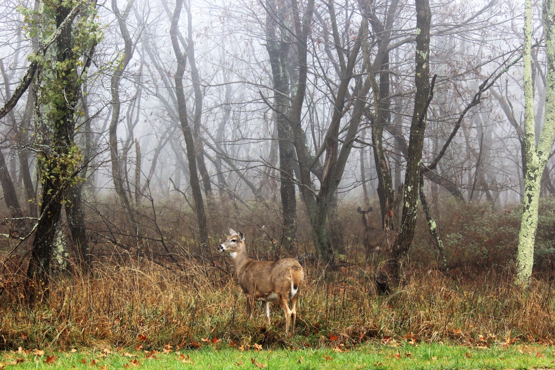
As with many national parks, you can get a broad sense of the land by driving its main artery. Similar to Acadia in that you can visually digest large swaths of the park from your car, or in the case of Shenandoah, from any of the 75 overlooks along Skyline Drive, where each overlook competes with the last. Nature’s one-upmanship. One view shyly permits a glimpse of a distant family of ridges, bathed in blue. Next, an offering of timeless forest, where colors compete for your adoration. All lovingly hovered over by a blanket of ever-changing clouds. Rising from the horizon, using an endless palate of color, a stygian sky may glide into velvet blue in minutes. Deeply bruised storm clouds silently drift between ridges. A breathtaking canvas of heavenly blue, melding into the textured blue of earth.

It’s difficult to explore Shenandoah without recognizing the role of the Civilian Conservation Corps (CCC). Franklin Delano Roosevelt took office during the depths of the Great Depression. In an effort to restore faith in the economy he created the largest series of public works projects in our history. Young men were given work building roads, bridges and dams across the country. Throughout the national parks, camps were established so that crews could develop trails, build lodging and in the case of Shenandoah, develop the 75 cutouts that allow us to view the park’s beauty from above. Each park owes a debt of gratitude to FDR. Without his foresight in creating the CCC, many of the trails and elements of infrastructure that we now take for granted wouldn’t exist. Here is a link to a brief, but well documented history of the Civilian Conservation Corps work in Shenandoah. https://www.nps.gov/shen/learn/historyculture/ccc.htm

Hiking to the top of Blackrock is not terribly difficult. The trail is a steady climb – not too steep. But nothing prepares you for what the top of Blackrock presents. Thousands of grey menacing boulders, seemingly pushed up from the earth, piled on top of one another in a truce established thousands of years ago. Sitting at the summit of this great glacial scrape of earth, looking down at the seemingly unending ridges and hollows, you could easily imagine the sense of wonder the early settlers of the valley must have felt. Countless millennia have done little to change what I was seeing. It was a wonderful moment.

Part of the fun of what I’m doing is meeting people from all over the United States and the world. Like Jeff from California, who had just finished driving from San Francisco in his VW Microbus. He had been on the road for two months, with his puppy and told me he had paid to camp only twice. That is no small feat. Then there’s the couple I met in the laundry, who have been traveling for the last for years. They lit up when telling me about the places they’ve been – the experiences they’ve shared. Each year they return to their hometown in Kentucky for a doctor’s visit and immediately set out on the road again. They struck me as two of the happiest people I’ve ever met and I admit to letting a little envy enter my heart.
I met Earl Varona and his friend Nellie on a turn-out while helping a woman break into her car where she had left her keys. Apparently I look like a seasoned thief. I asked Earl if he had climbed Old Rag Mountain, because due to weather I didn’t get a chance and the view is supposed to be stunning. He said yes, pulled out his phone and showed me a few very cool photos of himself at the summit. I asked him to email a photo so I could post. I think I also asked him to send a photo where hopefully he couldn’t be recognized, so I could say it was me at the summit. Thanks Earl. It was pleasure meeting you and Nellie. Stay in touch.
![image1[18219]](https://travelswiththebeardedman.files.wordpress.com/2017/11/image118219.jpg?w=1140)


I love your blog! It was so great to meet you. I’m going to bookmark your site. I became inspired to travel to all the national parks, but it would take me much longer (years) to accomplish.
LikeLike